Hazards as they happen
Crashes, roadworks, closures and flooding from your state's road authority, plus reports from other riders, spoken aloud as you ride so your eyes stay on the road.
RideAware plans three routes, scores each out of 100 using live crash data, roadworks, closures and traffic, then shows you every point it added or took away. Navigation is free and always will be.
Free during beta. Now riding in eight Australian cities.
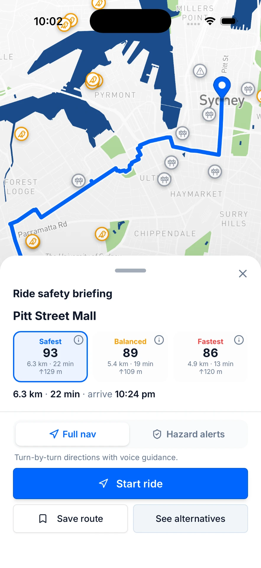
Other apps give you a blue line. RideAware gives you a number, then opens it up. Tap any route's score and you get the full ledger: every factor, what it added or took away, and which source it came from.
Live figures from a real Sydney route. Your score is built from the ride you are actually about to take, and from your own city's data.
RideAware is not one city's app with the rest bolted on. Each city reads its own road authority's live feed, its own crash record and its own cycleway network.
Transport for NSW
Transport Victoria
QLDTraffic
SA Department for Infrastructure and Transport
ACT Emergency Services Agency
Main Roads Western Australia
TasALERT
Road Report NT
Live hazards run in all eight. Crash history and cycleway mapping are live in six; Perth and Darwin fall back to OpenStreetMap cycling data while we source theirs.
Riding on a footpath is legal for adults in Queensland, South Australia, Western Australia, Tasmania, the ACT and the Northern Territory, and it is not in New South Wales or Victoria. RideAware routes to the rules where you actually are.
Crashes, roadworks, closures and flooding from your state's road authority, plus reports from other riders, spoken aloud as you ride so your eyes stay on the road.
Hit a closure, a pothole, a swooping magpie or a door-zone black spot, and report it in one tap. Every other rider on that street sees it within the minute.
Safest, Balanced and Fastest, each scored out of 100, each showing what it costs you in minutes. You decide the trade, not the app.
RideAware reads the recorded crash history of the roads you are about to ride and prices it into the score. Live in six of our eight cities.
Fall detection with an automatic text to up to three emergency contacts, carrying your location, and the 000 dialler ready to go.
The CO2 you have saved, kilometre by kilometre, and a number your workplace or council can actually count.
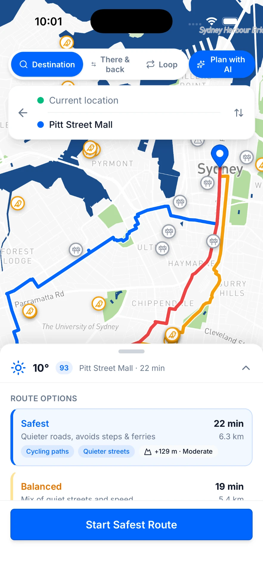
Instead of one blue line, RideAware plans several and rates each out of 100. We show you what safety costs you in minutes, up front, before you decide. The safest route is built to be the safest, and if anything caps its score we show you that line too.
Quieter streets and cycleways, avoids steps and steep descents.
5.9 km · 21 min · ↑112 m
+4 min · +9 safety
A mix of quiet streets and speed for the everyday commute.
5.4 km · 19 min · ↑109 m
+2 min · +5 safety
Direct lines for confident riders who know the traffic.
4.9 km · 17 min · ↑120 m
fastest · baseline
The recorded crash history of the roads on your route, from your state's open crash data.
Separated cycleways and shared paths outrank painted lines, and painted lines outrank nothing at all.
How much of the route puts you on an arterial with no provision for bikes.
Crashes, roadworks and closures reported minutes ago.
Live congestion along the route, discounted where you are physically separated from it.
Gravel, tram tracks, potholes and steps you would rather avoid.
Live conditions, and flood warnings we never discount.
Climb you have not asked for.
In season, from rider reports. It is Australia. It counts.
Sources: Transport for NSW, Transport Victoria, QLDTraffic, SA DIT, ACT ESA, Main Roads WA, TasALERT, Road Report NT, HERE, OpenStreetMap, Open-Meteo, and reports from RideAware riders. RideAware is not affiliated with any of them.
Some rides are not about getting anywhere. Tell RideAware how far you want to go and it builds a circuit from your front door and back, steering around the hazards and stitching together the quiet stuff. Or start from one of four rides it already knows.
Starts atCentennial Park
Roughly19 km
ThreadsBondi, Bronte, Coogee
Starts atBondi Beach
Roughly43 km
ThreadsCoogee, Maroubra, La Perouse
Starts atSurry Hills
Roughly51 km
ThreadsHarbour Bridge, The Spit, Manly, Dee Why
Starts atSydney CBD
Roughly79 km
ThreadsAnzac Bridge, Bay Run, Parramatta, Olympic Park, Cooks River
The four curated rides are Sydney for now. Build-your-own loops work in every city RideAware covers.
Any distance from about 2 km to about 150 km. Say how far you want to ride and RideAware draws a circuit that comes back to where you started.
Flat, mixed or hilly. Pick how much climbing you are in the mood for, and scenic or training for the character of the roads.
Do not like it? Ask again. Every loop is one draw of many. Tap again and you get a different circuit from the same start and roughly the same distance.
Every loop is safety-scored the same way a point-to-point route is, in all three tiers, so a quiet circuit and a fast one sit side by side with their scores.
Connect your Wahoo account once in Settings. From then on, any route in RideAware has a "Send to Wahoo" button. Pick the safest route, tap send, and it is on your head unit before you are out the door. No files, no cables, no share sheet.
Export your RideAware route, import it into Garmin Connect, then sync it to your head unit.
Once RideAware has built your route, tap Export and choose Download GPX. The file saves to your phone.
Open the file and share it to the Garmin Connect app, or head to connect.garmin.com on desktop and go to Training & Planning → Courses → Import. Give the course a name and save it.
Tip: on iPhone, tap the share icon on the downloaded GPX and pick Garmin Connect from the share sheet.
Garmin Connect pushes the course to your head unit next time it syncs, so keep the app open with your Garmin nearby. On the device, go to Navigation → Courses → Saved Courses, pick your route, and hit Ride.
Works with Garmin Edge and most Garmin cycling computers that support courses.
Your head unit will push the completed ride to Strava as normal.
We want Garmin to work the way Wahoo already does, with the route going straight to your head unit. Garmin's course API is not open to new apps at the moment. When that changes we will build it, and we will tell you here first.
Riding alone shouldn't mean being alone. Here's exactly what happens, and what doesn't.
On-device motion sensing recognises the impact signature of a crash while you're riding.
A loud alarm and countdown appear. Tap once, because you're fine or it was a dropped phone, and nothing else happens.
If the countdown runs out, up to three emergency contacts receive a text with your location, and the 000 dialler opens ready for you or a bystander to press call.
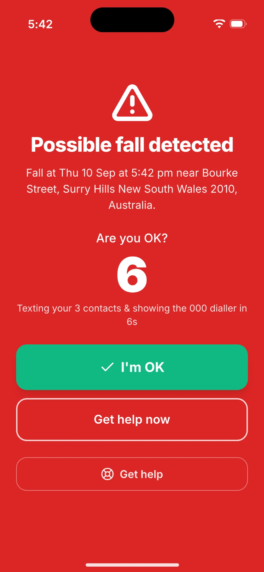
Automatic texting needs three things: you signed in, fall detection switched on in Settings, and at least one emergency contact saved. The contact fields appear once you turn fall detection on. If you ride signed out, RideAware still detects the fall and still opens the dialler, but it will not send the text for you.
While you ride, you can share a live link so the people who worry about you can follow along, without a phone call at the lights.
RideAware never calls emergency services for you. It opens the 000 dialler so a human makes that decision. Fall detection depends on your phone's sensors, battery and mobile coverage, and can miss falls or trigger on rough descents, so treat it as a backup, not a guarantee.
Join the RideAware beta and get safety-scored routing, live hazard alerts and fall detection on your next ride. Free while we are in beta.